Pages

Total Pageviews

Lampung (Indonesia) Travel Guide

          
        Lampung province is located at the extreme of south of Sumatra is overlooked, over flown by most tourists. In the past it was well known for its marvelous 'tapi' fabrics, some using real gold thread, and for its pepper. But today, it is the location from ambitious transmigration projects, resettling farmers from over-populated Java. It boasts volcanoes, wildlife reserve, megalithic remain and a superb coastline of deep-cut bays and wonderful beaches. Its capital is Bandar Lampung, is made up of twin cities that is Teluk Betung and Tanjung Karang. Way Kambas Nature Reserve is a 130,000 ha area of swamp and lowland forest with wild elephant, tapir and many other animals. Krui is the principal port on the virginal west coast of Lampung Province. There are vast gorgeous white sand beaches stretching for miles and kilometers and miles to the north and south.

Interesting Places

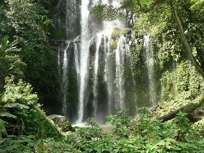
Putri Malu Waterfall

            
          Curup Putri Malu is located at Juku Batu village, Banjit subdistrict, about 46 km from Blambangan Umpu district, west Lampung. This waterfall is falling down cuved violet resembling human backs bathing, so this waterfall call" putri malu". It has beautiful green mountains panorama and surrounded wet tropical forest that still virgin. This places very good for adventure, rock climbing, camping, and just for fun with friends or spend holiday with family because have cool air, pure water and not far from population area.

Krakatau

        
          Indonesia belongs to one of the most volcanic and seismically active region in the world. There are 128 active volcanoes of which 76 had eruption in historic time. These were occurred in 3 belts which one of is Lesser Sunda Islands where Krakatau is located. The Indonesian Volcano logical Service classified those volcanoes as "class A" volcanoes, of which there 12 in Sumatra Island. One of those is Krakatau. Krakatau is located in South Lampung region in Sunda strait, between Java and Sumatera.

Pasir Putih Beach
           
          Pasir Putih beach is located in the south part of the City of Bandar Lampung City, about 20 kilometers from Bandar Lampung Sumatra acrossTrans street. Across the White Sands beach, shady trees are planted to cover the tourists after they feel like getting enough sun from walking down the beach. The water is clean and fresh to bath and play in, and the white sand gives peace to the tourists. This place is perfect for holiday spending. Besides the treat above, in the afternoon, the tourists can watch the sunset.
           If tourists want to watch the coral and sea creatures, they can swim until certain border or use motor boat until the middle part. This place has amazing kinds of fish, coral reef, and sea plants. White Sands beach is one of the tourism objects in Bandar Lampung for domestic and foreign tourists. For the sake of it, the cleanness of the place is preserved. To get there, tourists can use a personal car or public transportation. It is 30 minutes from Bandar Lampung. 

Way Kambas
        
          In the east part of Central Lampung there is a nature reserve named “Way Kambas“ which covers 130.000 hectares areas. To achieve Way Kambas, an asphalted road is built. It takes 2 hours drive from Bandar Lampung. In nature reserve, there is the first elephant-training centre in Indonesia to train wild elephants which are capture from outside the area because they have disturbed the people's fields. It is estimated there are about 500 elephants in Lampung, 250 of them are in Way Kambas. In this nature reserve, we can also find other wild animal such as Sumateran tigers, bears, tapirs and other animals such as deer, wild pigs and 286 bird species. If we visit Way kambas, we can see the process of training wild elephants in the elephants training centre, an attraction of elephants are playing football, elephant safari, elephants are swimming and on certain occasions.

Lampung Museum
          
          Lampung Museum is located in Z.A. Pagar Alam Street or just 5 km from the heart city of Tanjungkarang. It has 3.233 collections compiled from prehistory, Hindu, Buddha and Islamic Age. The Museum also collects local and foreign ceramic from China. We can also find the statue from Hindu-Buddhist period, household utensils from ancient time, old tapirs clothes, ancient traditional boat, war outfits etc.
          There we can see the ancient objects, remain of ceramic from China and Siam, or household utensils, which is from centuries ago. The museum is opened on Monday until Saturday. Taman budaya or art center is place for presenting the classical music and traditional dances of Lampung. It takes fifteen minutes to get there from center of town.

Ranau Lake
        
          Ranau Lake is surrounded by mountainuous highland and natural view. It is located in the West Lampung sharing border with South Sumatera Province. Cottages and boat are available. Liwa is the nearest town from Lampung (capital of West Lampung). Beauty of Chilli of nature that still natural made this area an area of the tour visit in Lampung West. In this area tourists could enjoy the beauty of the Ranau Lake that was surrounded by green hills as well as the Seminung Mountain that erect soared._Fresh and clear him Ranau Lake water very supportive for the swimming activity. Tourists could also enjoy the beauty of nature scenery ranau with boating the motor. Moreover for that wanted to be submerged in hot water, in this area also was gotten by the source of hot water.

Kota Agung Port
        
          Kota Agung is the capital of the Tanggamus Regency; one of 'old city' in Lampung province had the local port. Besides as the place of the fish landing, mode the transport of anchored sea and departed of connected territories in part: Tampang, Pemantang Sawah district, Tabuhan Island, etc. Sea with low pollution level in this gulf was rich in various kinds of the sea biota. The fish kind in part: tongkol-striped cloth, satay inflated, selar as well as cattle and lobster prawns lived in these waters. The Blue marlin presence in the certain season was attraction that rarely passed by the lover of sport fished. In the city that famous of the Watermelon Gulf often took place of the marriage ceremony activity or the tradition various ethnic. The implementation Mayor event, the Tanggamus Festival is become as incident-tourism that each year was displayed around March; this activity was centered on here.  

Way Laan
            
          Way Lalaan is a constitution gradually waterfall that have 200 m distance of one to others, from the flow of Way Lalaan river which mouth of a river to Semangka Bay. This location is in foot Valley of Tanggamus Mountain which just 2 Km from the Central Government of Tanggamus region or 80 Km from Bandar Lampung. This waterfall was unknowable since 1937 in Dutch Colonial Government, which make the cement ladder to waterfall valley. The facilities available are shelter, fitting room and park area.

Batu Tegi Dam
           
           Approaching the centre city Talang Padang district, in the right corner of the intersection, see to strike the plank of the indicator towards Tegi Stone Dam (Tegi = erect / stood - Lampung language). The location that about 20 km from this intersection is had the very wide area. When not making use of the person's vehicle, the visitor could use the taxi bike service from available bases to arrive at the location. The friendly inhabitants in pekon-pekon Pulau Panggung district around the location of the dam will enthusiastically answer the visitor's question of various matters about this area.

Megalithic Area
     
       
          For the site-interested person of archeology (tour-history & the culture), in Pulau Panggung district, tourists could visit to the complex megalithic and Bedil Stone inscription. The inscription that was made in Sriwijaya royal era proofs the inhabitants' existence in this territory in the past that was connected with this kingdom. Gotten by 3 complexes was separated that was adjacent in Pekon Bedil Stone of the Upstream and Lower; 10 minutes by vehicle to the north from the Tegi gate of the Stone Dam complex. Back to Talang Padang district territory. The producer area of the quality rice superior, namely Talang-Padang rice was the last district from Bandar Lampung side before entered to Kota Agung district territory. Apart from ethnic Lampung the A dialect and O dialect, the community in this dynamic territory was Semendo, Java, Sunda-Banten and Jaseng (the acronym Java-Serang) ethnic -the term in Lampung for the Banten ethnic group had spoke Java. Since several of their generations have assimilation interacting so as many that could hold a dialogue in five languages at the same time.       

Tabuan Island

           
       Tabuan island is to be a territorial of Tanggamus Regency that located in Teluk Semaka and the wide of the territory is about 600 hectares. In the future is planned by the government of the regency, will be built and functioned quay as the crossing quay of sea transportation and the fisherman location is widely about 2500 m. This location could be covered with the sea transportation, which took the motorboat or speedboat that took up about 1 trip hour from the seaport.
 
Foods
 
Seruit
 
     
        This food is the typical food of Lampung Province in the form of fried or baked fish sauce mixed with shrimp paste, tempoyak (processed durian) or mango. Species of fish that is usually used is river fish.     

Keripik Pisang Coklat
 
 
     These chips are processed form of banana species are processed into sour dishes that have high sales value. After the usual fried chips are still hot is mixed with chocolate powder until evenly distributed. It was a sweet banana sprinkled with chocolate has a different taste than other banana chips.    


Borobudur


History

There is no written record of who built Borobudur or why it was built. It was likely founded as a religious site in the 8th century at the peak of the Sailendra dynasty in central Java. The construction is thought to have taken a period of 75 years and completed in about 825 AD.
The confusion between Hindu and Buddhist dynasties and rulers in Java during this is a little baffling for visitors. Many Hindu and Buddhist monuments were constructed in the central Java region at this time. For example Borobudur and the nearby Hindu Prambanan temple compound were more or less contemporaneous. This, together with many records of royal marriages between Hindu and Buddhist nobles, has led academics to believe that there was little serious conflict concerning religion in central Java at this time. Such an assumption certainly helps the visitor understand the confusing archaeology of the region.
Borobudur lay abandoned and hidden for centuries under layers of volcanic ash and thick jungle growth. Nobody knows for sure why it was abandoned although the popular theory is that the local population just became disinterested when there were mass conversions to Islam in the 15th century. It was never forgotten entirely though with folklore ensuring that stories of the great monument lived on. 

Rediscovery

Following the Anglo-Dutch Java War, Java briefly was under British administration from 1811 to 1816. The British governor was Thomas Stamford Raffles (the founder of Singapore) and he took a great practical and academic interest in the history of the mystical island of Java. On a tour to Semarang in 1814, he was informed about a huge ‘lost’ monument deep in the jungles near Yogyakarta and he sent a Dutch engineer to investigate. It took 2 months to clear the jungle and partially reveal the amazing monument but it was not until 1835 that the complex was unearthed in its magnificent entirety.
Appreciation and protection was surprisingly slow to develop though and Borobudur became the domain of unscrupulous souvenir hunters. Modern-day archaeologists speculate that this was due to the European obsession with Ancient Egypt at the time – Borobudor was just too remote and too far away to get the attention it undoubtedly deserved. There was even a Dutch proposal to dismantle the monument and scatter it piece by piece to museums around the world. Thankfully, sense prevailed and by the end of the 19th century the site was left largely intact and a minor five year restoration programme was undertaken in 1907. 

Modern day Borobudur

In 1973, a major plan to restore Borobudur was created under the auspices of UNESCO. This huge project involved a complete overhaul of the monument between 1975 and 1982. The unsteady foundations were stabilized, everything was meticulously cleaned and a major drainage system installed. After the renovation was finished, UNESCO formally listed Borobudur as a World Heritage Site in 1991. Since then, the profile of Borobudur has increased enormously and it is now a major international tourist attraction. Its statues, reliefs and stupas have spawned millions of replicas which adorn properties worldwide.
As well as being the single most popular tourist attraction in modern day Indonesia, Borobudur has resumed its role as an important place of worship and pilgrimage for Indonesian Buddhists. Visitors should be understanding and respectful of this especially during major Buddhist holiday periods.
The 2006 Jogyakarta earthquake which badly damaged nearby Prambanan, left Borobudur unscathed.
  • PT Taman Wisata Candi Borobudur Prambanan Ratu Boko, Borobudur Temple Unit Office, Jalan Badrawati, Borobudur, Magelang 56553, Indonesia, +62 293 788266 (borobudur@borobudurpark.co.id), . The official government park authority for Borobudur

Get in

By plane

The nearest larger airports are in Yogyakarta's Adisucipto International Airport (JOG) and Solo's Adisumarmo International Airport (SOC). Both are well connected domestically and also offer some limited international connections to Singapore and Kuala Lumpur. It is possible, if one rushes oneself a bit, to visit Borobudur on a day trip from Bali or Jakarta. You can also fly direct to Semarang from Singapore with Batavia Air 4 times per week), and make your way to Borobudur from there (1.5hrs away). 

By bus

Public buses to Borobudur from Yogyakarta are aimed mostly at Indonesian visitors and only a few tourists venture aboard. If you are adventurous though, the Trans-Jogya service runs from central Yogyakarta to Jombor bus terminal in northern Yogyakarta (Rp3,000) where you can change to another bus to get to Borobudur. It takes about 60 to 90 minutes and should cost around Rp10-15,000 one way, but bargain with the bus staff to get a good price.
Buses run regularly from Magelang to Borobudur via Muntilan and are widely advertised there. Journey time of about 1 hour.
To get to and from Prambanan, take a Yogyakarta bus and get down at Jombor Terminal (90 min, Rp 15,000 for visitors, Rp 7,000 for Indonesians). From Jombor take TransJogya route 2B to Prambanan (45-60 min, Rp 3,000). It will require 3 bus changes- 2B from Jombor to Terminal Condong, 3B from Condong to Maguuro (Jl. Solo) and 1A/B from Maguuro to Prambanan

By minibus

Travel agents in Yogyakarta sell door-to-door minibus tour packages for around Rp 75,000, which is a good deal and a straightforward way to reach the monument, although some operators may stop off at Batik and Silver factories along the route. 

By car

Yogyakarta is about 40 minutes south of Borobudur by car. Most of the route is on a well-maintained (for Indonesia) four-lane (in many places) highway and there are frequent bus services (see above). A taxi from Yogyakarta to Borobudur costs around Rp 200,000 or Rp. 225,000 from the airport. 

See

Mount Merapi is an active volcano situated nearby Borobudur. In late October and throughout November 2010 a series of volcanic eruptions occured at Mount Merapi. In excess of 353 deaths were reported with many injured from severe burns and respiratory damage.
By early December the eruptive activity of Merapi had subsided considerably and on 3 December the warning level was reduced from level 4 to level 3. A reduced exclusion zone radius of 2.5 km was announced at that time.
Further volcanic activity in the area including explosive eruptions, lava flows, lahars, hot ash, pyroclastic heat clouds and molten debris remains possible.
Borobudur was heavily affected by the eruptions. Volcanic ash from the Mount Merapi eruptions fell upon the temple complex, which is 28 kilometres (17 mi) to the west, south west of the crater. A layer of ash up to 2.5 centimetres (1 in) fell on the temple statues during early November, killing nearby vegetation, with experts fearing that the acidic ash might damage the historic site. The temple complex was closed for extended times during the eruptions due to the ashfall. Sunrise tours and access to the temple may unavailable at times due to the cleaning up after the eruption of Merapi.
Please check the details of the current situation thoroughly before booking or undertaking a visit to the area
Entry into Borobudur costs:
  • US$ 15 / Rp 135,000 for adult non-Indonesians
  • US$ 8 / Rp 72,000 for registered students
  • Rp 15,000 for Indonesian adults
The international ticket office uses an exchange rate of Rp 9,000 = US$1
The site is open to the public from 6AM to 5PM. However, the Manohara Hotel (see Sleep) runs a daily Borobudur Sunrise Tour for Rp 320,000 for foreigners while Rp 220,000 for Indonesians, which gets you a flashlight and a lift up to the temple gate at 4:30AM, in time to see the sunrise and explore for an hour and a half before the hordes arrive. This is well worth the money. Hiring a guide who can explain the reliefs well costs Rp 75,000 per hour, with a minimum time of 2 hours. You should ask for a guide in the evening before going to tour in the morning.
Climbing the pyramid takes some effort, and the dark stone absorbs the sun's heat rapidly to make walking and climbing quite hot by early afternoon. If you have but modest stamina or heat tolerance, you should start as early in the day as possible, and take plenty of water with you.
Borobudur consists of a single stupendously large structure, which can be divided into layers as follows:
  • The platform at the base of the structure, which was clearly post the original construction and hides some reliefs, is of uncertain provenance and function. The main theories are that the platform was added to censor reliefs depicting earthly desires or — rather more likely — to buttress the subsiding structure and prevent it from collapsing. A section of the platform has been excavated at the southeast corner, showcasing some of the hidden reliefs underneath.
  • The bulk of the structure consists of four square terraces connected by steep staircases. Each terrace has reliefs in two layers on both sides, recounting the story of the Buddha's past lives and his enlightenment. The "correct" way to view the reliefs is to start from the east gate (the main entrance) and circulate clockwise.
  • After the square terraces the structure suddenly opens up to reveal the final four circular terraces. Comparatively plain and unadorned, there are no more reliefs here, just several hundred domes housing half-hidden Buddha statues (many headless, some lost entirely). 
  • The peak of the structure is a central stupa. The two chambers inside the stupa are empty, and it is unclear whether they were empty from the beginning as a representation of nirvana, or whether they originally contained now lost statues.
  • You can discover 6 different postures of buddha's statue for bottom level to the top. They are "contact with earth", "giving and helping", "meditation", "fearlesness", "teach and learn", "turning of the wheel of dharma".
  • The rather lacklustre museum, a few hundred meters to the north of the temple, does a haphazard job of presenting the restoration process. Perhaps the most interesting bits are the exhibition of the Karmawiharga reliefs, with explanatory comments, and the photo gallery of old 19th-century shots of the complex before it was restored. 

Around Borobudur

Between Yogyakarta and Magelang lies the volcanic Kedu Plain. This was clearly an important area in pre-10th century Javanese history as it contains a whole host of ruins (both Buddhist and Hindu) dating from the same era as Borobudur and easily reached from there. The most accessible of these together make an interesting use of the late part of the day on the way back to Yogyakarta after you have seen Borobudur. 

  •  
  • Candi Mendut. A Buddhist temple that is thought to have acted as a waypoint on the road to Borobudur. It was first discovered in 1834 and holds the distinction of being the first ancient monument in the whole of Indonesia to be restored (from 1897). Some of the statues and reliefs here are of the highest quality and it is well worth a visit. Menut is notable as the start of the modern day Waisak procession. From Borubudor head back towards Muntilan on the main road for 3 km and Candi Mendut is signposted off a small left hand turn off the main road.
  • Candi Pawon (Branjalan) is only 2 km from Borobudur and you cannot miss driving past it when heading back towards Muntilan and Yogyakarta. It is on a direct line with Borobudur and Mendut and is again thought to have been am ancient waypoint. This temple was restored in the early 20th century.
  • Candi Ngawen is in Ngawen village just to the south of Muntilan on the main road heading towards Yogyakarta (about 15 km from Borobudur). This Buddhist temple dates from 824 AD and has some interesting wall reliefs.
  • Candi Canggal dates from the 8th century and is at Gunung Wukir on the main road heading back towards Yogyakarta from Muntilan. The best landmark is the Chinese cemetery which you should look for on the right after leaving Muntilan. A road leads west (right) just after you pass this cemetery. Follow this until the end and walk the last few minutes to Candi Canggal. 

Do

  • To avoid the crowds, avoid the weekends when hoards of domestic tourists visit, along with the occasional school trip of students, sent by their teachers to practice their English with unsuspecting foreign tourists.
  • On Waisak, Buddha's birthday (held on the night of the full moon in May), an elaborate and colorful multi-day Buddhist festival is held at Borobudur, culminating in a candle-lit procession from Candi Mendut to Borobudur. Walking the Waisak procession route from Borobudur to Candi Mendut (or vice versa) at any time is an excellent experience.
  • If you are still at Borobudur in the late afternoon, return to the top level stuppas for sunset. It is often very quiet at this time and the sunset behind the mountains to the west is quite magical.
  • Be nice to the locals. Seriously. There is a lot written in travel guides about the pushy nature of the vendors at Borobudur. And they can be a little annoying it must be said. But a few friendly no's usually do the job. Yogyakarta is a great seat of learning in Indonesia and you will often find many students at Borobudur who are keen to be friendly with you. Take this how it is meant - they are genuinely friendly and rightly very proud of their heritage and keen to talk to you about it. 

Buy

Persistent touts hassle tourists on the approaches to the temple but are usually kept away from the temple itself. Be firm and polite about your intentions and they will soon get the message. Be careful when you exit the temple as there are confusing signs pointing to exit gates which lead you through a maze of stalls.
If you do intend to buy some souvenirs here then make sure your bargaining skills at their best

Eat

  • Manohara Restaurant. Inside the park on the grounds of the hotel of the same name, this resort-style restaurant serves up standard Indonesian fare and beautiful views of Borobudur. Mains from Rp 15,000. 

Sleep

The vast majority of visitors stay in Yogyakarta and a few in Magelang. It is though well worth spending the night at Borobudur as this will give you a chance the following morning to get to the temples before the crowds arrive. Indeed, if you really want to explore and understand this magnificent monument, overnighting in the immediate area is vital. 

Budget

There are a number of losmen and basic hotels in the village of Borobudur just south of the park entrance. Owing to the site's popularity with tourists prices are, by Indonesian standards, somewhat inflated for what you get.
  • Adrian. This budget hotel offers double rooms with prices from Rp 120,000 to Rp 175,000 with inside bathroom but no hot water and A/C. The higher priced rooms have TVs.
  • Lotus Guest House, Jl Medang Kamulan 2, Central Java, Borobudur, Indonesia (located on northern road near Borobudur), +62 293 788281
  • Pondok Tinggal, Jl Balaputradewa 32, Brojonalan, Borobudur, Magelang, Indonesia (located several hundred meters on eastern road of Borobudur, between Borobudur and Pawon temple), +62 293 788145 (info@pondoktingal.com),  Good value option less than 1 km from the entrance to Borobudur. From Rp 200,000
  • Rajasa Hotel, Jl Badrawati No2, Borobudur, Magelang., +62 293 788276. Only about 200 metres from the main entrance. Very popular with Indonesian families and the walls are thin, so can get noisy. Good service and good food for the price. From about Rp 300,000

Mid-range

  • Manohara Hotel, Jl Badrawati, Borobudur, Magelang 56553, Indonesia, +62 293 788680 (manohara@borobudurpark.co.id),. Formerly Taman Borobudur Guest House, this friendly resort-style hotel is located inside the Borobudur park, run by the park authority and is just 200 metres from the temple entrance. The grounds are beautifully landscaped and the views are great, but the rooms are little more than functional (a/c, hot water). Still, a room booked here is Rp 575,000 net, which is excellent value as the price includes breakfast and entry to Borobudur for two. Food is excellent. This is the best option for visitors wanting to overnight at Borobudur and gain entry the next morning before the masses arrive. You can also rent a bike here which will cost only Rp 10,000 per hour. Biking in the surrounding villages is recommended. From Rp 575,000.  
  • Ning Tidar Hotel, Jl Purworejo-Magelang KM 5, Magelang, Central Java, Indonesia, +62 293 314316 (info@ningtidar.com), . This hotel is about 6 km from Borobudur and is in the middle of nowhere apart from a smokey internet cafe nearby, so it is not the most convenient location. However, it is a good option when the closer hotels are booked out, as they frequently are. It is a very nice property for the price and it can organize taxis to Borobudur. 24 hour restaurant service. From Rp 350,000.  
  • Saraswati Borobudur, Jl Balaputradewa No10, Borobudur, Magelang, Indonesia, +62 293 788843 (marketing@saraswatiborobudur.com), . This is a beautiful hotel with views of Borobudur, a swimming pool, and the most gracious staff. The rooms are large with the full range of amenities. Room rates are often deeply discounted (up to 60%) so be sure to ask before you go. Breakfast is included in your rate as is transportation to Borobudur (guide is optional). From US$ 79

Splurge

  • Amanjiwo, +62 293 788 33 (amanjiwo@amanresorts.com),. Super luxury resort run by the Aman Group, located just 3 kilometres from Borobudur on the temple's south side and offering all the facilities you would expect. Rated by some as one of the very best hotels in Asia, if not the world. From US$ 650

Contact

The telephone area code for Borobudur is the same as Yogyakarta - 0274
  • Ambulance: 118.
  • Police: 110. 

Get out

  • The Hindu temples of Prambanan, about an hour away by car, make the perfect complement to Borobudur.
  • The cultural splendour of Yogyakarta is about 90 minutes by bus. 

Bengkulu (Indonesia) Travel Guide

 
          Bengkulu is the smallest and lowest populated province of Sumatra. Bengkulu province is located on the southwest coast of Sumatra. It occupies of 19,831 sq. km area and has about one million populations, comprising mostly Rejang, Malay, Bugis and Chinese ethnic ancestry people. Bukit Barisan mountain range constitutes its northeastern border, beyond which laid of South Sumatra province and Jambi province. The province protected by a stretch of mountains, which soon flow into the mighty Bukit Barisan. Tigers and elephants wander through the remains of the original rainforest, where exotic rafflesia's and orchids grow.  

Interesting Places

Muko-muko Beach

            
           Muko-muko Beach is located at Kecamatan Muko-muko Utara which share the border with the West Sumatera province and Jambi province. The distance between this area and the city of Bengkulu is 276 m, connected by good asphalt road and a lot of 4-wheels vehicles transportation available.
           This beach is located in the conjunction between two big river estuary, Manjuto River and Salagan River. There are spruce-firs grow along the beach where the tourist can have swimming, sun-bathing or fishing in the conjunction. 

Bukit Daun

           
         This is a protected recreation forest located between Bengkulu and Curup, about 45 km from Bengkulu. It is inhabited by a great variety of animal species. Located in a sparsely populated region of Sumatra, Bukit Daun forms a twin volcano with Gedang volcano, which is truncated by a 3-km-wide probable caldera. The 600-m-wide summit crater of Bukit Daun contains a crater lake; a smaller crater lake is found at Tologo Kecil on the SSW flank. No historical eruptions are known from Bukit Daun, although active fumaroles occur in the SSW flank crater.

Enggano Island
     
          Enggano island is located about 177 km south of Bengkulu city. The beautiful Enggano beach sea garden of Enggano Island, located at the group of atol around this island where we can see the life of the colorful sea coral and sea water fish, even from the sea surface. 
          There are a several clans who lives in Enggano island; Kaharuba clan, Kaarubi clan, Kaitora clan, Kaahoao clan, and Kauno clan. Diving and ocean park a natural view of beautiful shallow coral sea. To reach this island can use boat at  the harbour of Baai island or a small boat at Bintuhan seaport. Don't forget to see the traditional society with their native’s Enggano dances.

Bukit Kaba Crater


          Kaba Volcano is located at Rejanglebong Regency, Bengkulu, Sumatra Island. There are 8 craters show historical explosive activity. The summit area of Kaba volcano contains three high peaks - Bukit Kaba, Bukit Itam (1893 m) and Bukit Malintang (1713 m) with three craters among them called Kaba west-old crater, Kaba middle-new crater and kaba vogel sang crater, one of them is still active. Vapors incessantly escape from 12 fissures in the earth and hot water springs are found in the vicinity. For those who like mountain climbing, this crater complex is in the sulfurous mountains.

Dendam Tak Sudah Lake
  
          Dendam Tak Sudah Lake is situate about 6 KM from Bengkulu town. It is small lake but very popular at Bengkulu because of the history. There are young man and young lady( lovers) but disagree with their parents in the past. In the end they suicide in this places.
         This lake have beutifull panorama and red looks blue from far away. There is a peculiar plant which just can found at this lake but not at other place, it is a water orchid called Vanda Hooke Riana. This lake surrounded by a mountains, can be used for fishing, canoeing and other water sports.
      
Palik Beach
          
         Palik beach is located in north Bengkulu district. It has beautiful scenery. This beach very good for refreshing with our family or our friend. Palik beach have perfect for swim and sunbathing. Visitors can also do snorkeling and diving.

Emas Lake

           
          Inhabited by schools of carp, this lake is located near Curup, in Rejang Lebong regency. Emas Lake means GOLD LAKE, a place for recreation. Anyhow, the place is look so nice, a lake with abundant of- Water Lily -a small Lotus flower, a small island at the center, a play ground for children, Rental boat, and many rest house, small cafe and restaurant, some villa at the slope of hill side. Many cottages have been built around the lakeside to accommodate the holidaymakers.

Bioa Embun Waterfall

           
        Bioa Embun Waterfall is a beautiful waterfall  with cold and clean water. When one going to Suban Hot Spring at Bengkulu, at first one can visit it waterfall just before reaching the Suban Park, it was on the right side, stepping down is with little difficulties because there are, as local peoples said " thousnds step".with its 70 meters height.

Panjang Beach
          
         This beach is located 3 km west of Bengkulu town, and stretches for approximately 7 km. Many cottages are available as well as other recreational facilities. The Long, Clean, white-sand beach is good for sunbathing. There is a public swimming pool and tennis facility, along with restaurants, seaside cottages and hotels. This long white clean beach is hard to find in another Indonesian beaches, which is good for sunbathing and has some marine attractions. 

Raflesia Arnoldi
          
         The world's largest flower is found in many areas in Bengkulu forests, on the slopes of Bukit Barisan Mountains. The flower has a diameter of about one meter in full bloom. It has no visible root or stem, and no leaves. The weigth up to 7 kg, it takes the buds up to 8 months to mature. The flower stays in bloom from 1-15 days and can be seen during the months of September-December. Rafflesia Arnoldi is a big Flower in the worlds, if one visit Rejang Lebong, the Flower was stand at the City Center of CURUP as a monument, that is why, the people call Bengkulu is A LAND OF RAFFLESIA, or in Indonesian means BUMI RAFFLESIA, because in a certain seasons, if we are lucky, we can see a beautiful flower of Rafflesia, in the forest, which appear in periodic of 5 years or more.

Fort Marlborough
         
        Fort Marlborough is an old fortress Built in 1713 till 1719 by British East India. As a British colonial heritage, Marlborough is located in the main street of Bengkulu. Inside the building, there is a subway connected to the outside. It was as the second strongest fort built by British in the east after Fort George in Madras, India. Sir Thomas Stamford Raffles in 1817 was appointed by British Administration as Lieutenant Governor of Bengcoolen (Bengkulu), during his administration, a botanist Joseph Arnold discovered the world largest flower at Manna district, southern parts of Bengkulu, the Flower is well known as Raflesia Arnoldi. The British ruled the region more than 100 years, then in 1825 under the London treaty, the administration was Handing over to the Dutch until Indonesia get the Independence Day in 1945.
           
Tabot Ceremony
          
         One of the special events in this province is the Tabot Festival. Tabot ceremony is an interesting festival ceremony, which recalls the death of Hasan and Husen, the grandchildren of the Prophet Mohammed, who were killed in a fight to defend Islam. The Tabot feast is held annually, in the Islamic month of Muharram. It is known as the festival of fifty colorful towers (tabots), which are made of bamboo and decorated with colored paper. This tabot ceremony is commemurated by Bengkulu people who are descents from India benggala, performed every yera from 1 till 10 Muharram 61 Hijriah in Bengkulu City. The ceremony is held between 09.00 pm to 01.00 am.

Foods
Kue Perut Punai
          
         This cake was named for the brown pigeon stomach like pigeon feathers in the stomach. Manufacturing process is just a mixture of rice flour, palm sugar and salt, fried crisp. It feels soft inside and outside Loud sweet.

Tempoyak
 
       
         Tempoyak is a dish made from fermented durian fruit. In consumption as a companion side dish when eating rice. Sambal Tempoyak typical Bengkulu has a unique taste that is cooked with spicy taste, commonly added to fish or sea or river fish with shrimp.

South Sumatra (Indonesia) Travel Guide

     
         South Sumatra Province is situated on the eastern side of Bukit Barisan mountain range South Sumatra province is relatively flat, nevertheless fertile, as numerous rivers crisscross and meander through out the region. Palembang is its capital city and as the gateway to the province, lies right on the banks of the great Musi River, 60 km upstream and navigable by oceangoing vessels. No wonder that most major social and economic activities should center in Palembang and Musi River where the region's pride, Ampera Bridge, is found as well.   

Interesting Places

Sriwijaya Site
  
        
        Place of tourist attraction sites are located in Karang Anyar village in the district ie. West Ilir Palembang municipality. Place in've Officially opened by President Soeharto on December 22, 1994 with the laying of the replica back Kedukan Bukit inscription. The history of the inscription is telling two armies laksa Sriwijaya Wanua Srijayanasa build on the Saka year 606 (684 AD) at the foot of Mount Siguntang.
 
Lawang Agung Waterfall
 
         
        Lawang Agung Waterfall is located in the Lawang Agung Lama village, Jarai sub district about 2 hours from Lahat city, south Sumatera. You can go there by car, motorcycle. A long the road you can see beautiful scenery, cool air, tea plantation, Dempo mountain and feeling decreased road conditions and little rocky. It is so fascinating. Arrived in this waterfall you can see water that so strong, pure water and cool air. It make this waterfall so wonderfull and you can't forget this event.

Lubuk Linggau

          
         Lubuklinggau is Lahat town, gateway to Pasennah Highlands. Dotting this mountain plateau are carved megaliths, tombs, pillars and other stone ruins thought to date from date 100 A.D. These are considered the best examples of prehistoric stone sculpture in Indonesia. Oddly shaped rocks have been fashioned into figures of armed warriors riding elephants, wrestling buffaloes or fighting snake. There are dolmens, sanctuaries, colored painting, and other works of art in the area of volcanic Mount Dempo.
        Sulap hill is located in the east south of Lubuk Linggau, and become one of nature tourism objects also as the center of recreation and resort with 68.593.18 hectares width. This area is stayed at 471 m on the sea level. There is an irrigation construction in this town, which built by the Dutch in 1941 for irrigation. This water irrigation is come from Kelingi River. 

Kemaro Island

         
         Kemaro Island is a river delta in musi, about 5 km to the downstream Ampera Bridge. On this island there is a monastery. In celebration of Cap Go Me for Chinese people Chinese people, including thousands who came from various cities and even from overseas visited the island to conduct Kemaro prayer or pilgrimage. This celebration lasts 2 - 3 days. Kemaro the island can also be seen at the Pertamina refinery and River Plaju Gerong and PT Pusri fertilizer plant next to the various activities on the river Musi.
 
Limas House
  
         
         Plenty authentic traditional houses of Palembang people called Rumah Limas. Usually built in a very big size, this unique style of house is called Rumah Limas due to its ceiling; the architecture of the ceiling has the format of “limas” similar to pyramid but slightly different at the very peak.
        Rumah Limas is built with a very, very strong wood material called Kayu Ulin and usually will last for a long time; but unfortunately it is often more expensive to build one compare to regular houses with bricks, thus, today there are not many new Rumah Limas built; those who still live in Rumah Limas are normally known as middle to upper class families.
 
Musi Lake
 
         
         Musi River is both very broad as well as long, comparable to those found on the big island of Kalimantan, formerly Borneo. The river flows right through the city, cutting it in two halves called the Ulu bank and the Ilir bank and linked by a bridge of considerable size and length, called Ampera Bridge. If the visitors do not care to make an interesting or unique boat trip down the river, they could still take a walk halfway over the bridge to see the vast panorama surrounding them, rare at any other place in Indonesia. 
         Down below they will see unbelievable traffic of boats, big and small, crisscrossing water lines without accidents as if steered by the most able navigators. From the same spot both halves of the city are clearly visible as well. And if the times were right, sunrises and sunsets as witnessed from the bridge would be an unforgettable sight of beauty. Worthwhile noticing are the floating restaurants and shops on both sides of the river, and other curious scenes of daily habits of the city's inhabitants.
       There is an annual event, which is held around the Independence Day, each 17th of August, and is known as Bidar Race in which boats measuring 24.5 m long and only 0,75 m wide compete. Each boat carries as many as 50 oarsmen.

Ampera Bridge

         
        The bridge that spread above Musi River is becomes the main characteristic of Palembang city. It was built on 1962 - 1965. Ampera Bridge has 78m high of tower. However, the special feature of this bridge that it can be opened and closed, the mechanism is no longer working, whereas is fact, it is the only bridge in Indonesia with the open-and-closed mechanism. Now it is only history. The bridge has to be lifted up of the middle shares each time there every king sized ship, with height above nine meters, will pass by quickly. Both for going to downstream and also which going to the upstream.
 
Dempo Mountain
 
         
         Mount Dempo is one of the natural tourism objects in Pagaralam. It is the highest peak in South Sumatra and might be reached directly from Palembang by car, after spending 6 hours more or less for about 295 kilometers. Grown in northern Sumatra (Indonesia) Highlands. The liquor tends to be light with a hint of body and meatiness. Dempo Volcano is located at Lahat Regency, South Sumatra Province while little part belongs to Muna Regency of Bengkulu Province. Geographically, it lies at 04° 02'' SL and 103° 08'' EL. The volcano has two peaks called Dempo and Merapi. The highest peak names Merapi with 3173 m high above sea level, while Dempo is about 3049 m. Dempo is a prominent 3173-m-high strata volcano that rises above the Pasumah Plain of SE Sumatra. Remnants of 7 craters are found at or near the summit, with volcanism migrating to the WNW with time. The historically active summit crater of Mount Dempo contains a 400-m-wide lake, located at the NW end of the crater complex. 
 
Punti Kayu
 
         
          This recently built recreational complex covers 50 hectares area, consist of four parts: an amusement park, a recreation park, a natural forest, and a man-made lake. In this complex are to be found a children's playground, a cultural park, a souvenirs shop, restaurants and an information booth. Because of its proximity to the capital and easy accessibility, this complex actually caters mainly to the local inhabitants of Palembang city, however, international tourists may enjoy passing a calm day here to watch urbanites amuse themself.
 
Palembang Museum
 
       
         The state museum is relatively new building and was erected in 1977 only; however, its collection of around 2000 relics and antiquities originating from the province would make a real treat for the visitors who would come here. We can see ancient household articles, utensils, looms, hunting tools, a bridal room and some preserved animals of the region.
        One of museum in Palembang city is Museum of Sultan Mahmud Badaruddin II. It was used as the palace of Sultan. It has an imposing semi circular staircase and was built by the Dutch in 1823, which located near Musi River. Another museum is Balaputra Dewa Museum which located 5,5 km from the center of Palembang.

Curup Tenang Waterfall

        
        It is the highest waterfall in South Sumatra, located near Bedegung village in Tanjung Agung district, about 56 kilometers South of Muara Enim Regency. Rich in the number of small as well as big rivers flowing through this province, waterfalls of various sizes come with them too. Tenang_ waterfall where the water smashes down from 90 meters height into a deep pool and further downstream in a strong current. It can reach by public transportation and takes 2 hours from Palembang, however, less by private car. The Muara Enim regency, two hours from Palembang, is a land of rivers and waterfalls. 
 
Ranau Lake
 
         
        Ranau Lake is located in Banding Agung district, 125 Km from Baturaja, the capital of Oku Regency. Ranau is an 8 x 13 km caldera partially filled by the crescent-shaped Ranau Lake. It is surrounded by hills and has mount Seminung background. Beneath the Mount Seminung, there is a source of natural warm water. A morphologically young post-caldera strata volcano, Mount Semuning, was constructed within the SE side of the caldera to a height of more than 1600 m above the caldera lake surface.
        For most people, Ranau Lake is the climax of a visit to the western highlands of South Sumatra. This blinking Crater Lake is located in the old caldera of Mount Seminung (1340 meters), an active volcano on the border of Lampung province. It's 16 km long and 9 km wide, and has a depth of 300 meters. The climate in these highlands is nice cool and the remote location offers wealthy vegetation, crystal clear water and beautiful trips to a nearby fall, hot source and an island in the lake. However the lake is very popular among the local population in the weekends, it's not spoiled by tourism yet.

Putri Cave

          
         The cave is situated at the edge of Padang Windu Village, Pengandonan district, about 35 Km from Baturaja. It is 156 m long and 8-20 m wide. The maximum height is 20 m. There are many stalactites and stalagmites and a stream in the cave, which empties into Ogan River. The rocks can be very slippery once in a while, so good shoes with a good profile are not to be forgotten. Guides with lights and torches guide the visitors and give detailed information (mostly in Indonesian) about legends, which are strongly connected, to the caves. The main cave is about 150 meters long; the widest point is about 15 to 20 meters. In some places the ceiling is 12 meters high, on other places only 1,5 meters. The ceiling is scattered with hundreds of bats; when light disturbs them, they will fly out all together and just miss the visitors. To enter the deeper parts of the caves you have to be slender enough to pass very narrow points. Legendary stories tell about a king which had his palace in this cave, and every room has it's own story. The stala.
 
Serelo hill 
 
         
         Serelo is a hill that located about 20 km from Lahat city. Beneath the hill, there is a special complex for taming, training and educating elephant. There are about 25 elephant, which have been trained to show off some attractions to the visitor/ tourist.
 
Sambilangan National Park
 
   
         In the eastern part of the region there is a 45.000 square hectares Sembilang Wildlife Reserve. Sembilang National Park was setup in 2003 in southeastern Sumatra. Over 350,000 hectares of peat swamp, freshwater swamp and mangroves, the park is host to a few critically endangered Sumatran tigers. Sembilang is such a paradise for various kinds of protected birds like lesser adjutant stork, milky stork, spot billed pelican, wild duck, eagle, hornbill, etc. There are also two kinds of Sumatra crocodile, i.e. crocodilus porosus and tomistoma slegeli. In Sembilang river there also lives irrawadi dolphins and humpback dolphins. 
 
Napal Licin Cave


         Napal Licin is a cave of stalactites and stalagmites. To visit the place we have to take boat to upstream Rawas River. It is a new developing tourism object in Musi Rawas. This is the new tourism object for the visitor who came to Musi Rawas.
         If we interested to make an adventure, try to visit Kerinci Seblat National Park. There are many kind of flora and fauna there, that cannot found in other area. We can find Rafflesia flower and also hundreds of birds, such as; crested parrot, and the other.  
 
Foods
 
Tekwan
 
      
          This is typical Tekwan Meatball Palembang. Meatball is a typical Indonesian food and can be found in all parts of Indonesia, so digemarinya Meatball has many flavor variations. To which of Kilkenny has the distinction that is made from fish that berkuah Tenggiri shrimp broth. Served with vermicelli, sliced bengkoang, a sprinkling of fried onions, a sprinkling of leaves sledri and given little food vinegar and soy sauce.
 
Kacang Merah Ice
 
   
             Red Bean Ice usual at present as a cooling refreshment from the spicy foods like Pempek Palembang, Lenggang, Tekwan and Models. Ice is very easy to make because only a mixture of red bean stew ditambakan sugar syrup, slices of jackfruit, sweetened condensed milk, sweet basil or grass jelly is sometimes added. Shavings and served with ice cubes.  

Pempek

        
         Pempek is unifying people of Palembang food with Chinese. This recipe is a concoction of local communities by mixing starch with a lot of fish meat obtained Musi river, the two ingredients are then given a little salt and boil then preserved. If you’d like presented then fried and given a spicy sauce called cuko.
 
Lempok
 
 
          Lempok is lunkhead with durian material which is a mainstay of traditional processed food society of South Sumatra. Dodoo dried durian is processed from durian fruit. Distinctive taste and smell are very rarely found in other areas in Indonesia.